Media Center
Inspiring the world through GIS
November 16, 2022 : 12:46 pm
20 years back, we wouldn’t have imagined the developments and technological advancements our nation has embodied today. As we celebrate the World GIS Day, lets take GIS as the perfect example of this.
GIS is short for Geographic Information System, a system that creates, manages, analyzes and maps all kinds of data. Our GIS team of just 4 members, are working tirelessly to collect all types of data required to understand the geographic context, descriptive information and location data of Hulhumalé, Gulhifalhu and Thilafushi. This team manages land parcel data and helps to visualize information in the form of maps and other web applications.
GIS plays a major role in improving the planning process and effectively monitoring the development progress of Hulhumalé, Thilafushi and Gulhifalhu.
How does GIS work?
GIS technology applies geographic science with tools for understanding and collaboration. It helps people reach a common goal: to gain actionable intelligence from all types of data.
- Maps: Maps are the geographic container for the data layers and analytics you want to work with. GIS maps are easily shared and embedded in apps, and accessible by virtually everyone, everywhere.
- Data: GIS integrates many different kinds of data layers using spatial location. Most data have a geographic component. GIS data includes imagery, features, and base maps linked to spreadsheets and tables.
- Analysis: Spatial analysis lets you evaluate suitability and capability, estimate and predict, interpret and understand, and much more, lending new perspectives to your insight and decision-making.
- Apps: Apps provide focused user experiences for getting work done and bringing GIS to life for everyone. GIS apps work virtually everywhere: on your mobile phones, tablets, in web browsers, and on desktops.
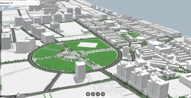
Our GIS Team has successfully launched an online 3D scene viewer which helps to visualize the current development progress of Hulhumalé. This application would enable viewers to better understand the planned developments within the context of the built environment. You can search the location of any physical structure, towers, and flats and also get the basic information of that place including the number of floors, neighborhood etc.
We are proud to say that Hulhumalé drone imageries are more up to date than Google Maps, all thanks to our GIS & Survey Team.
Have a look at the base map gallery here to check for yourself through MyHulhumalé Portal.